
Barkas:Internet map 1024.jpg
Resolusi biasa (1.280 × 1.280 piksel, ukuran berkas: 1,27 MB, tipe MIME: image/jpeg)
Meet Android Auto.
It's the best of your phone.
On your car display.
Get Started
Connect your phone. Now hit the road.
Connect your phone to your car display—your Android apps show up onscreen, just like that. Tap to get driving directions or talk to send a text. Even call your mom, hands-free. Android Auto is made to help you focus on the road. And have fun along the way. Just connect and go.
Check compatibility Get help from Google Assistant. With Google Assistant on Android Auto, keep your eyes on the road and your hands on the wheel. Use your voice to get help finding routes and playing your favorite songs. You can even ask for the latest news or check the weather.
Say "Hey Google" Press steering wheel button Tap app icons Tap mic icon1
Navigation tools to find a better route.
Directions from here to wherever. With Google Maps, Waze, or another map on your car's display, you can quickly see what's nearby and navigate there. You'll also get real-time alerts to help you avoid traffic. Even ask Google Assistant to find gas along the way, or quickly share your ETA with just a tap. Just say where to. And then go.
Find routes Real-time alerts1 Places on the way Share ETA See more navigation apps
Call and chat features to stay connected.
Keep in touch with Google Assistant. Google Assistant can read your messages out loud. And you can write back with just your voice, or select a smart reply with just one tap. From making calls to using chat apps, Android Auto makes driving less distracting.
Make calls Messaging1 Chat apps See more communications apps
Entertainment so you can enjoy the ride.
Say what to play next. Take your media on the road. And control it all with your voice. Pause your road-trip playlist and pick up where you left off. Just talk to start a new audio book. Blast that one song for the hundredth time.
Play music Hear news Listen to audio books Find all your media apps
Connect your phone to your car for a better drive. From highway to backroad and everything in between, Android Auto lets you do more while driving. That means a seamless connected experience. All powered by Android.
Unlock your car with your phone.
Read more
See more with split-screen functionality. Read more
Get more done with Google Assistant. Read more
Keep up to date on the road. Read more
How to use Android Auto. 1 Step 1 Check your car. Make sure your car or aftermarket stereo is compatible with Android Auto.
Check compatibility 2 Step 2 Check your phone. If you have Android 9 or below, get the Android Auto app on your phone. With Android 10, Android Auto is built in—so you don’t need the app to get started.
Download Android Auto 3 Step 3 Connect and go. Connect your phone to your car with a USB cable and see Android Auto on your car display. Some phones and cars can connect wirelessly - check this , and check with your car manufacturer to see if your car has this capability.
Get more answers. Have more questions? Get the answers you need and hit the road with Android Auto.
What are the requirements to run Android Auto on my car display?
An Android phone running Android 8.0 and up with a data plan.
A car or stereo that's compatible with Android Auto.
.
For wireless connection: A compatible phone () and a compatible car or a supported aftermarket car stereo from JVC, Kenwood, or Pioneer. Check with the manufacturer to see if wireless is supported.
Which apps can I use on Android Auto? Android Auto makes it easy to access your favorite music, media, and messaging apps in the car. .
Is Android Auto available in my country?
Android Auto is currently available in the following countries:
Argentina Australia Austria Belgium Bolivia Brazil Canada Chile Colombia Costa Rica Denmark Dominican Republic Ecuador France Germany Guatemala India Indonesia Ireland Italy Japan Mexico Netherlands New Zealand Norway Panama Paraguay Peru Philippines Poland Portugal Puerto Rico Russia Singapore South Africa South Korea Spain Sweden Switzerland Taiwan Thailand Turkey United Kingdom United States Uruguay Venezuela
Which countries can I use Google Assistant for Android Auto? Google Assistant for Android Auto is available in the following countries:
Australia Belgium Canada (English) Denmark France Germany India (English) Indonesia Netherlands Norway Poland Portugal South Korea Sweden Thailand Turkey United Kingdom United States
How do I download the Android Auto App? Go to the Google Play Store, download the Android Auto app and run it anytime you’re on the road. . As a reminder, phones with Android 10 and above don't need the app to run Android Auto.
How do I get Android Auto to run on my car display?
For most compatible cars or aftermarket stereos, simply plug in your phone using a USB cable. If your car display supports wireless connection, you must pair your phone with your car’s bluetooth for set-up. After set-up, depending on your car, either the phone will automatically connect or the Android Auto app icon will appear on your car display.
Is my car or aftermarket stereo compatible with Android Auto?
See which models can run Android Auto. .
Which cars and phones support wireless connection with Android Auto?
An increasing number of makes and models of vehicles and phones support wireless connections to Android Auto. Availability is rapidly evolving and varies based on geography and trim level. , and inquire with car manufacturer to check if your car supports this capability.
How can I get more help with Android Auto?
Visit our and to learn more about Android Auto and get help.
Follow Us Find Android on Twitter Find Android on Instagram Find Android on YouTube Find Android on Facebook Find Android on LinkedIn Privacy & Safety Accessibility More from Android Support For Enterprise For the press For Developers Some features and devices may not be available in all countries. Subject to availability.
Some features and availability vary by OEM and/or device manufacturer.
1Sequences are shortened and simulated.
2Wireless connection is only supported when paired between certain devices and certain vehicles.
Privacy Policy
LanguagesEnglish
|
|
Deutsch: Dieses Bild war 2010 in der 39. Kalenderwoche das Bild der Woche in der Malaysischen Wikipedia
English: This image was selected as a picture of the week on the Malay Wikipedia for the 39th week, 2010.
Македонски: Сликава е избрана за слика на неделата на малајската Википедија за XXXIX недела од 2010 година.
Bahasa Melayu: Imej ini merupakan gambar pilihan mingguan di Wikipedia Bahasa Melayu untuk minggu ke-39, 2010.
Français : Cette image est sélectionnée en tant qu'image de la semaine sur la Wikipédia Malaisienne pour la 39ème semaine de 2010.
Italiano: Questa immagine è stata selezionata come Immagine della settimana su Wikipedia in malese per la XXXIX settimana del 2010.
Nederlands: Deze afbeelding is gekozen als afbeelding van de week op de Maleisische Wikipedia voor week 39 van 2010.
Русский: Эта иллюстрация была выбрана изображением недели в малайском разделе «Википедии» для недели номер 39 2010 года.
Українська: Ця ілюстрація була вибрана зображенням тижня в малайському розділі «Вікіпедії» для тижня номер 39, 2010 року.
Tiếng Việt: Hình này đã được chọn làm hình ảnh của tuần trên Wikipedia tiếng Mã Lai trong tuần thứ 39, năm 2010.
|
| This image was selected as a picture of the week on the Persian Wikipedia for the 13. week, 2011. |
Ringkesan
| Panyandra |
Беларуская (тарашкевіца): Частковая мапа інтэрнэта, заснаваная на дадзеных ад 15 студзеня 2005 г. на opte.org. Кожная лінія намалявана паміж двума вузламі, злучая два IP-адрасы. Даўжыня лініі паказвае часавую затрымку (пінг) паміж двума вузламі. Мапа ўяўляе меньш за 30% сетак клясы C даступных для збора дадзеных у 2005 годзе. Колер лініі адпавядае яе месцазнаходжаньню адпаведна RFC 1918. Выкарыстоўваюцца наступныя колеры:
Català: Mapa parcial d'Internet basat en la informació obtinguda pel lloc opte.org el 15 de gener de 2005. Cada línia dibuixada entre dos nodes representa l'enllaç entre dos adreces IP. La longitud de les línies és proporcional al temps d'espera entre els nodes. La imatge representa el 30% de les xarxes tipus C accessibles pel programa de recol·lecció de dades al 2005. El color de les línies correspón a la seva classificació RFC 1918 de la següent manera:
Deutsch: Teile einer "Karte" des Internets, basierend auf Daten von opte.org am 15.01.2005. Jede Linie beschreibt zwei Knotenpunkte, welche zwei IP-Adressen repräsentieren. Die Länge der Linien beschreibt die Verzögerung zwischen den Knotenpunkten. Diese Karte beschreibt weniger als 30% der Klasse-C-Netzwerke, welche Anfang 2005 von dem Datensammelprogramm erreicht werden konnte. Die Linien sind farblich entsprechend der RFC 1918 Addressbereiche gekennzeichnet:
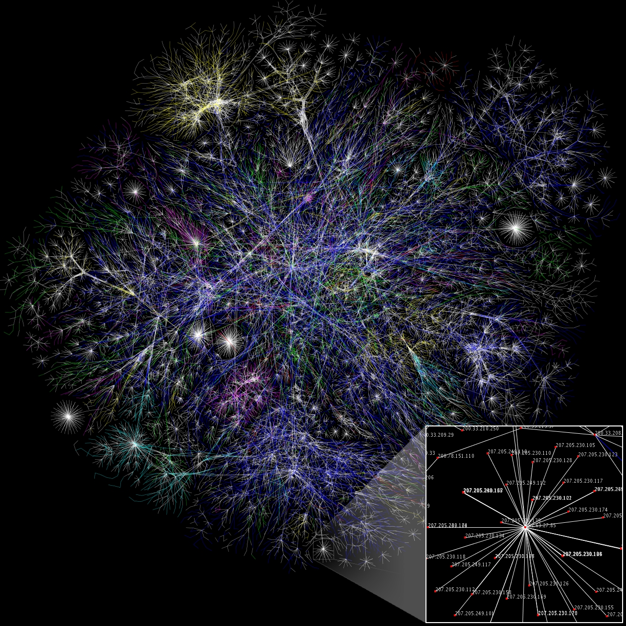
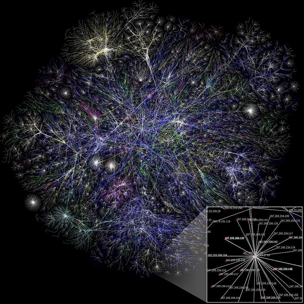
English: Partial map of the Internet based on the January 15, 2005 data found on opte.org. Each line is drawn between two nodes, representing two IP addresses. The length of the lines are indicative of the delay between those two nodes. This graph represents less than 30% of the Class C networks reachable by the data collection program in early 2005. Lines are color-coded according to their corresponding RFC 1918 allocation as follows:
Español: Mapa parcial de Internet basado en la información obtenida del sitio opte.org el 15 de enero de 2005. Cada linea dibujada entre dos nodos representa el enlace entre dos direcciones IP. La longitud de las líneas es proporcional al tiempo de espera entre los nodos. La imagen representa 30% de las redes tipo C accesibles al programa de colección de datos de 2005. El color de las lineas corresponde a su clasificación RFC 1918 de la siguiente manera:
Suomi: Osittainen kartta Internetistä perustuen 15. tammikuuta 2005 dataan, löydettävissä osoittesta opte.org. Jokainen viiva on piirretty kahden verkon solmukohdan väliin edustaen kahta IP osoitetta. Viivojen pituuden kuvastavat viivettä näiden kahden solmukohdan välillä. Viivat on värjätty verkkotunnusten mukaan seuraavasti:
Français : Carte partielle d'Internet, basée sur les données de opte.org du 15 juin 2005. Chaque ligne relie 2 nœuds, représentant 2 adresses IP. La longueur de chaque ligne donne une indication du délai entre les 2 nœuds. Moins de 30 % des réseaux de classe C accessibles par le programme de collecte de données début 2005 sont représentés. Les lignes sont coloriées selon le code de couleur défini par la RFC 1918 :
Nederlands: Deelkaart van het internet, gebaseerd op de gegevens die op 15 januari 2005 op opte.org beschikbaar waren. Elk van de lijnen verbindt twee knooppunten, en representeert dus twee IP adressen. De lengtes van de lijnen zijn maatgevend voor de looptijd tussen de twee knooppunten. Deze grafiek vertegenwoordigt nog geen 30% van de klasse C netwerken die vroeg in 2005 voor het data collectie programma bereikbaar waren. De kleurcodering van de lijnen correspondeert op de volgende wijze met hun RFC 1918 toewijzing:
Polski: Mapa części Internetu oparta o stan z 15 stycznia 2005, dane ze strony opte.org. Każda linia wytyczona jest między dwoma węzłami, reprezentującymi dwa adresy IP. Długość linii wskazuje na opóźnienie między tymi węzłami. Ten wykres reprezentuje niecałe 30% sieci klasy C osiągalnej przez programy zbierające dane na początku 2005 roku. Linie są pokolorowane w zależności od odpowiadającym im alokacjom RFC 1918 w następujący sposób:
Русский: Частичная карта интернета, основанная на данных от 15 января 2005 г. на opte.org. Каждая линия нарисована между двумя узлами, соединяя два IP адреса. Длина линии показывает временную задержку (пинг) между двумя узлами. Карта представляет менее чем 30% сетей класса C доступных сетей для сбора данных в 2005 году. Цвет линии соответствует ее местоположению согласно RFC 1918. Используются следующие цвета:
|
| Tanggal | Original upload: December 1, 2006 |
| Sumber | Originally from the English Wikipedia; description page is/was here. |
| Juru pangarang | The Opte Project |
| Idin (Nganggo manèh barkas iki) |
Berkas ini dilisensikan dengan lisensi Creative Commons Atribusi 2.5 Generik.
|
| Vèrsi liya |
Derivative works of this file: |
File history at English Wikipedia
| Date/Time | Dimensions | User | Comment |
|---|---|---|---|
| 17:00, 1 December 2006 | 1280×1280 (1.27 MB) |
Internet | (Slightly fixed small box location.) |
| 16:48, 1 December 2006 | 1280×1280 (1.27 MB) |
Ilocos.net | (Newer version, higher res.) |
| 05:29, 3 November 2006 | 1280×1280 (1.27 MB) |
WikiRoulete | (== Summary == I created this small partial map of the Internet from the <a href="/w/index.php?title=2005-01-15&action=edit" class="new" title="2005-01-15">2005-01-15</a> data found [http://www.opte.org/maps/ here] using a slightly different rendering technique than was used to generate the maps there. Each line is drawn between two nod) |
Sajarah kaca
Klik nang tanggal/wektu kanggo ndeleng berkas kiye nang wektu kuwe mau.
| Tanggal/Wektu | Miniatur (''thumbnail'') | Ukuran | Panganggo | Komentar | |
|---|---|---|---|---|---|
| siki | 30 Oktober 2012 16.06 | | 1.280 × 1.280 (1,27 MB) | Mmxx | Reverted to version as of 15:51, 7 January 2007 |
| 30 Oktober 2012 01.30 |  | 1.280 × 1.280 (1,56 MB) | Rotatebot | Bot: Image rotated by 90° | |
| 7 Januari 2007 15.51 |  | 1.280 × 1.280 (1,27 MB) | Dodek | This image was copied from wikipedia:en. The original description was: {{FeaturedPicture|Internet Map}} == Summary == I created this small partial map of the Internet from the 2005-01-15 data found [http://www.opte.org/maps/ here] using a slightly d |
Pranala berkas
1 kaca kiye duwe pranala maring berkas kiye:
Panggunané barkas sajagat
Wiki liya ngisor iki nganggo barkas iki:
- Kanggo ing af.wikipedia.org
- Kanggo ing als.wikipedia.org
- Kanggo ing anp.wikipedia.org
- Kanggo ing ar.wikipedia.org
- معلومة
- يوتابايت
- إنترنت
- زيتابايت
- إكسابايت
- معلوماتية حيوية
- شبكة عصبونية اصطناعية
- حوسبة علمية
- شبكة حاسوب
- علم الأحياء المحوسب
- عمود الإنترنت الفقري
- حوسبة متوازية
- ماثووركس
- حوسبة سحابية
- تصنيف:حوسبة متوازية
- نظرية التخلل
- قانون مور
- رسم بياني عشوائي
- تأثير الشبكة
- نظام دعم قرار
- إس آي كورتكس SC
- شبكة دلالية
- تصنيف:حوسبة سحابية
- نظرية الشبكات
- قالب:شريط بوابات
- قالب:شريط بوابات/شرح
- رأس المال الاجتماعي
- شبكة اجتماعية
- طوبولوجيا شبكة
- حوسبة لينة
- نموذج الشبكة الهرمية
- إينار
- شبكات العالم الصغير
- قالب:علم الشبكات
- معامل تجميع
- تصوير علمي
- محمد الشارخ
- التاريخ المعاصر
- وحدة:Portal/images/ح
- تصنيف:بوابة حوسبة علمية/مقالات متعلقة
- الإنترنت في العراق
- وحدة:Portal/images/ح/شرح
- بوابة:حوسبة علمية
- بوابة:حوسبة علمية/واجهة
- تصنيف:حوسبة علمية
- بوابة:القرن 21
Deleng naraguna liyané sadonya saka kaca iki.